OpenLayers学习笔记2——坐标转换问题
Posted 疯子加天才
tags:
篇首语:本文由小常识网(cha138.com)小编为大家整理,主要介绍了OpenLayers学习笔记2——坐标转换问题相关的知识,希望对你有一定的参考价值。
参照别人的添加marker的demo来改造时,发现无论怎样更改经纬度,都是停留在同一个位置。过了一两天突然想起可能是坐标参考的问题,尝试搜了一下,果然是这个问题。问题是这样子的:
WMTS中地图的坐标参考系是102100(具体是哪个不清楚),如下图所示:

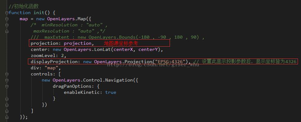
而我在初始化地图时设置的参数如下图所示:projection属性设置的是‘EPSG:102100’,displayProjection属性设置的是‘EPSG:4326’,也即经纬度显示。
projection
{String} Set in the map options to specify the default projection for layers added to this map. When using a projection other than EPSG:4326 (CRS:84, Geographic) or EPSG:3857 (EPSG:900913, Web Mercator), also set maxExtent, maxResolution or resolutions. Default is “EPSG:4326”. Note that the projection of the map is usually determined by that of the current baseLayer (see baseLayer and getProjectionObject).
displayProjection
{OpenLayers.Projection} Requires proj4js support for projections other than EPSG:4326 or EPSG:900913/EPSG:3857. Projection used by several controls to display data to user. If this property is set, it will be set on any control which has a null displayProjection property at the time the control is added to the map.

因此如果要利用经纬度进行定位标记的话,需要进行坐标转换,即EPSG:4326—>EPSG:102100,主要用到OpenLayers.LonLat的transform函数,代码如下:
- //坐标转换
- function corTransform(lon, lat) {
- var proj = new OpenLayers.Projection("EPSG:4326");
- var lonlat = new OpenLayers.LonLat(lon, lat);
- lonlat.transform(proj, this.map.getProjectionObject());
- return lonlat;
- }
- /**
- * APIMethod: transform
- * Transform the LonLat object from source to dest. This transformation is
- * *in place*: if you want a *new* lonlat, use .clone() first.
- *
- * Parameters:
- * source - {<OpenLayers.Projection>} Source projection.
- * dest - {<OpenLayers.Projection>} Destination projection.
- *
- * Returns:
- * {<OpenLayers.LonLat>} Itself, for use in chaining operations.
- */
- transform : function (source , dest) {
- var point = OpenLayers.Projection.transform(
- {\'x\' : this.lon , \'y\' : this.lat} , source , dest);
- this.lon = point.x;
- this.lat = point.y;
- return this;
- } ,
- 顶
- 2
- 踩
以上是关于OpenLayers学习笔记2——坐标转换问题的主要内容,如果未能解决你的问题,请参考以下文章