OpenLayers 3 基础知识
Posted
tags:
篇首语:本文由小常识网(cha138.com)小编为大家整理,主要介绍了OpenLayers 3 基础知识相关的知识,希望对你有一定的参考价值。
OpenLayers 是一个专为Web GIS 客户端开发提供的javascript 类库包,用于实现标准格式发布的地图数据访问。
要在你的网页中使用OpenLayers(现用版本:v3.19,1),需要在head中做以下引用:
OpenLayers css样式引用:
<link rel="stylesheet" href="https://openlayers.org/en/v3.19.1/css/ol.css" type="text/css">
OpenLayers js文件引用:
<script src="https://openlayers.org/en/v3.19.1/build/ol.js"></script>
对低版本浏览器的API填充(polyfill):
<script src="https://cdn.polyfill.io/v2/polyfill.min.js?features=requestAnimationFrame,Element.prototype.classList,URL"></script>
polyfill:大致是在低版本浏览器对API新特性不支持时,作为辅助实现API功能的东西。
通过以上的标签连接到OpenLayers 相应的文件。简单的说,有了上面的几个标签,在body部分写脚本时相应的类(如下面的:ol.Map,ol.layer.Tile等)才会起作用。下面贴一个完整的简单例子:
<!DOCTYPE html>
<html>
  <head>
    <title>Accessible Map</title>
    <link rel="stylesheet" href="https://openlayers.org/en/v3.19.1/css/ol.css" type="text/css">
    <!-- The line below is only needed for old environments like Internet Explorer and android 4.x -->
    <script src="https://cdn.polyfill.io/v2/polyfill.min.js?features=requestAnimationFrame,Element.prototype.classList,URL"></script>
    <script src="https://openlayers.org/en/v3.19.1/build/ol.js"></script>
    <style>
      #map:focus {
        outline: #4A74A8 solid 0.15em;
      }
    </style>
  </head>
  <body>
    <div id="map" class="map" tabindex="0"></div>
    <button id="zoom-out">Zoom out</button>
    <button id="zoom-in">Zoom in</button>
    <script>
      var map = new ol.Map({
        layers: [
          new ol.layer.Tile({
            source: new ol.source.OSM()
          })
        ],
        target: ‘map‘,
        controls: ol.control.defaults({
          attributionOptions: /** @type {olx.control.AttributionOptions} */ ({
            collapsible: false
          })
        }),
        view: new ol.View({
          center: [0, 0],
          zoom: 2
        })
      });

      document.getElementById(‘zoom-out‘).onclick = function() {
        var view = map.getView();
        var zoom = view.getZoom();
        view.setZoom(zoom - 1);
      };

      document.getElementById(‘zoom-in‘).onclick = function() {
        var view = map.getView();
        var zoom = view.getZoom();
        view.setZoom(zoom + 1);
      };
    </script>
  </body>
</html>
对OpenLayers的使用有了一个简单的认识后,开始在OpenLayers官网http://openlayers.org/上下载API进行更深入的学习。
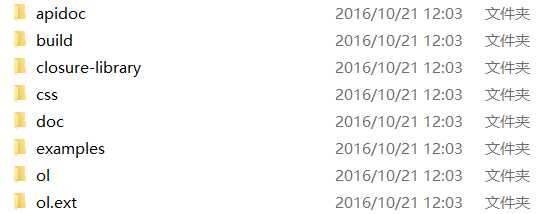
下载后的API文件结构如下:

每个文件夹下存放什么内容需要自己使用时慢慢探索清楚。
以上是关于OpenLayers 3 基础知识的主要内容,如果未能解决你的问题,请参考以下文章