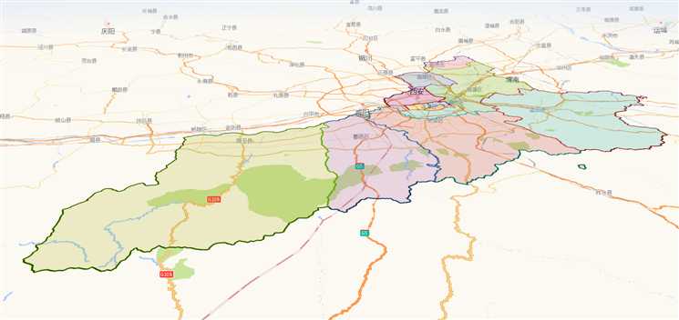
高德地图行政区域划分(西安)
Posted shixingwen
tags:
篇首语:本文由小常识网(cha138.com)小编为大家整理,主要介绍了高德地图行政区域划分(西安)相关的知识,希望对你有一定的参考价值。
本来是支持地图下钻的,去掉注释代码即可
<!doctype html>
<html lang="zh-CN">

<head>
    <!-- 原始地址://webapi.amap.com/ui/1.0/ui/geo/DistrictExplorer/examples/index.html -->
    <base href="//webapi.amap.com/ui/1.0/ui/geo/DistrictExplorer/examples/" />
    <meta charset="utf-8">
    <meta name="viewport" content="initial-scale=1.0, user-scalable=no, width=device-width">
    <title>行政区浏览</title>
    <link rel="stylesheet" type="text/css" href="./area.css">
</head>

<body>
    <div id="outer-box">
        <div id="container" tabindex="0"></div>
        <div id="panel" class="scrollbar1">
            <ul id="area-tree">
            </ul>
        </div>
    </div>
    <script type="text/javascript" src=‘//webapi.amap.com/maps?v=1.4.15&key=您申请的key值‘></script>
    <!-- UI组件库 1.0 -->
    <script src="//webapi.amap.com/ui/1.0/main.js?v=1.0.11"></script>
    <script type="text/javascript">
    //创建地图
    var map = new AMap.Map(‘container‘,
       resizeEnable: true,
       rotateEnable:true,
       pitchEnable:true,
       zoom: 11.8,
       pitch:75,
       rotation:-15,
       viewMode:‘3D‘,//开启3D视图,默认为关闭
       buildingAnimation:true,//楼块出现是否带动画
       expandZoomRange:true,
       zooms:[3,20],
       center:[108.907941,34.2463]  // 108.907941,34.2463
    );
    //just some colors
    var colors = [
        "#3366cc", "#dc3912", "#ff9900", "#109618", "#990099", "#0099c6", "#dd4477", "#66aa00",
        "#b82e2e", "#316395", "#994499", "#22aa99", "#aaaa11", "#6633cc", "#e67300", "#8b0707",
        "#651067", "#329262", "#5574a6", "#3b3eac"
    ];

    AMapUI.load([‘ui/geo/DistrictExplorer‘, ‘lib/$‘], function(DistrictExplorer, $)

        //创建一个实例
        var districtExplorer = window.districtExplorer = new DistrictExplorer(
            eventSupport: true, //打开事件支持
            map: map
        );

        //当前聚焦的区域
        var currentAreaNode = null;

        //鼠标hover提示内容
        var $tipMarkerContent = $(‘<div class="tipMarker top"></div>‘);

        var tipMarker = new AMap.Marker(
            content: $tipMarkerContent.get(0),
            offset: new AMap.Pixel(0, 0),
            bubble: true
        );

        //根据Hover状态设置相关样式
        function toggleHoverFeature(feature, isHover, position)

            tipMarker.setMap(isHover ? map : null);

            if (!feature)
                return;


            var props = feature.properties;

            if (isHover)

                //更新提示内容
                $tipMarkerContent.html(props.adcode + ‘: ‘ + props.name);
                //更新位置
                tipMarker.setPosition(position || props.center);


            $(‘#area-tree‘).find(‘h2[data-adcode="‘ + props.adcode + ‘"]‘).toggleClass(‘hover‘, isHover);

            //更新相关多边形的样式
            var polys = districtExplorer.findFeaturePolygonsByAdcode(props.adcode);
            for (var i = 0, len = polys.length; i < len; i++)

                polys[i].setOptions(
                    fillOpacity: isHover ? 0.5 : 0.2
                );


        //监听feature的hover事件
        districtExplorer.on(‘featureMouseout featureMouseover‘, function(e, feature)
            toggleHoverFeature(feature, e.type === ‘featureMouseover‘,
                e.originalEvent ? e.originalEvent.lnglat : null);
        );

        //监听鼠标在feature上滑动
        districtExplorer.on(‘featureMousemove‘, function(e, feature)
            //更新提示位置
            tipMarker.setPosition(e.originalEvent.lnglat);
        );

        //feature被点击
        districtExplorer.on(‘featureClick‘, function(e, feature)
            debugger
            var props = feature.properties;

            //如果存在子节点
            if (props.childrenNum > 0)
                //切换聚焦区域
                switch2AreaNode(props.adcode);

        );

        //外部区域被点击
//         districtExplorer.on(‘outsideClick‘, function(e)
//
//             districtExplorer.locatePosition(e.originalEvent.lnglat, function(error, routeFeatures)
//
//                 if (routeFeatures && routeFeatures.length > 1)
//                     //切换到省级区域
//                     switch2AreaNode(routeFeatures[1].properties.adcode);
//                  else
//                     //切换到全国
//                     switch2AreaNode(100000);
//
//
//             ,
//                 levelLimit: 2
//             );
//         );

        //绘制区域面板的节点
        function renderAreaPanelNode(ele, props, color)

            var $box = $(‘<li/>‘).addClass(‘lv_‘ + props.level);

            var $h2 = $(‘<h2/>‘).addClass(‘lv_‘ + props.level).attr(
                ‘data-adcode‘: props.adcode,
                ‘data-level‘: props.level,
                ‘data-children-num‘: props.childrenNum || void(0),
                ‘data-center‘: props.center.join(‘,‘)
            ).html(props.name).appendTo($box);

            if (color)
                $h2.css(‘borderColor‘, color);


            //如果存在子节点
            if (props.childrenNum > 0)

                //显示隐藏
                $(‘<div class="showHideBtn"></div>‘).appendTo($box);

                //子区域列表
                $(‘<ul/>‘).addClass(‘sublist lv_‘ + props.level).appendTo($box);

                $(‘<div class="clear"></div>‘).appendTo($box);

                if (props.level !== ‘country‘)
                    $box.addClass(‘hide-sub‘);


            $box.appendTo(ele);


        //填充某个节点的子区域列表
        function renderAreaPanel(areaNode)

            var props = areaNode.getProps();

            var $subBox = $(‘#area-tree‘).find(‘h2[data-adcode="‘ + props.adcode + ‘"]‘).siblings(‘ul.sublist‘);

            if (!$subBox.length)
                //父节点不存在,先创建
                renderAreaPanelNode($(‘#area-tree‘), props);
                $subBox = $(‘#area-tree‘).find(‘ul.sublist‘);


            if ($subBox.attr(‘data-loaded‘) === ‘rendered‘)
                return;


            $subBox.attr(‘data-loaded‘, ‘rendered‘);

            var subFeatures = areaNode.getSubFeatures();

            //填充子区域
            for (var i = 0, len = subFeatures.length; i < len; i++)
                renderAreaPanelNode($subBox, areaNode.getPropsOfFeature(subFeatures[i]), colors[i % colors.length]);


        //绘制某个区域的边界
        function renderAreaPolygons(areaNode)

            //更新地图视野
            map.setBounds(areaNode.getBounds(), null, null, true);

            //清除已有的绘制内容
            districtExplorer.clearFeaturePolygons();

            //绘制子区域

            districtExplorer.renderSubFeatures(areaNode, function(feature, i)

                var fillColor = colors[i % colors.length];
                var strokeColor = colors[colors.length - 1 - i % colors.length];
                debugger
                return
                    cursor: ‘default‘,
                    bubble: true,
                    strokeColor: strokeColor, //线颜色
                    strokeOpacity: 1, //线透明度
                    strokeWeight: 3, //线宽
                    fillColor: fillColor, //填充色
                    fillOpacity: 0.2, //填充透明度
                ;
            );

            //绘制父区域
            districtExplorer.renderParentFeature(areaNode,
                cursor: ‘default‘,
                bubble: true,
                strokeColor: ‘black‘, //线颜色
                strokeOpacity: 1, //线透明度
                strokeWeight: 1, //线宽
                fillColor: null, //填充色
                fillOpacity: 0.2, //填充透明度
            );


        //切换区域后刷新显示内容
        function refreshAreaNode(areaNode)

            districtExplorer.setHoverFeature(null);

            renderAreaPolygons(areaNode);

            //更新选中节点的class
            var $nodeEles = $(‘#area-tree‘).find(‘h2‘);

            $nodeEles.removeClass(‘selected‘);

            var $selectedNode = $nodeEles.filter(‘h2[data-adcode=‘ + areaNode.getAdcode() + ‘]‘).addClass(‘selected‘);

            //展开下层节点
            $selectedNode.closest(‘li‘).removeClass(‘hide-sub‘);

            //折叠下层的子节点
            $selectedNode.siblings(‘ul.sublist‘).children().addClass(‘hide-sub‘);


        //切换区域
        function switch2AreaNode(adcode, callback)

            if (currentAreaNode && (‘‘ + currentAreaNode.getAdcode() === ‘‘ + adcode))
                return;


            loadAreaNode(adcode, function(error, areaNode)

                if (error)

                    if (callback)
                        callback(error);


                    return;


                currentAreaNode = window.currentAreaNode = areaNode;

                //设置当前使用的定位用节点
                districtExplorer.setAreaNodesForLocating([currentAreaNode]);

                refreshAreaNode(areaNode);

                if (callback)
                    callback(null, areaNode);

            );


        //加载区域
        function loadAreaNode(adcode, callback)

            districtExplorer.loadAreaNode(adcode, function(error, areaNode)

                if (error)

                    if (callback)
                        callback(error);


                    console.error(error);

                    return;


                renderAreaPanel(areaNode);

                if (callback)
                    callback(null, areaNode);

            );


//         $(‘#area-tree‘).on(‘mouseenter mouseleave‘, ‘h2[data-adcode]‘, function(e)
//
//             if (e.type === ‘mouseleave‘)
//                 districtExplorer.setHoverFeature(null);
//                 return;
//
//
//             var adcode = $(this).attr(‘data-adcode‘);
//
//             districtExplorer.setHoverFeature(currentAreaNode.getSubFeatureByAdcode(adcode));
//         );


//         $(‘#area-tree‘).on(‘click‘, ‘h2[data-children-num]‘, function()
//
//             var adcode = $(this).attr(‘data-adcode‘);
//
//             switch2AreaNode(adcode);
//         );

//         $(‘#area-tree‘).on(‘click‘, ‘.showHideBtn‘, function()
//
//             var $li = $(this).closest(‘li‘);
//
//             $li.toggleClass(‘hide-sub‘);
//
//             if (!$li.hasClass(‘hide-sub‘))
//
//                 //子节点列表被展开
//                 var $subList = $li.children(‘ul.sublist‘);
//
//                 //尚未加载
//                 if (!$subList.attr(‘data-loaded‘))
//
//                     $subList.attr(‘data-loaded‘, ‘loading‘);
//
//                     $li.addClass(‘loading‘);
//
//                     //加载
//                     loadAreaNode($li.children(‘h2‘).attr(‘data-adcode‘), function()
//
//                         $li.removeClass(‘loading‘);
//                     );
//
//
//         );

        //全国
        switch2AreaNode(610100);
    );
    </script>
</body>

</html>
效果预览
以上是关于高德地图行政区域划分(西安)的主要内容,如果未能解决你的问题,请参考以下文章
