基于卫星测深的牙买加沿岸水深测量
Posted xiaokcehui
tags:
篇首语:本文由小常识网(cha138.com)小编为大家整理,主要介绍了基于卫星测深的牙买加沿岸水深测量相关的知识,希望对你有一定的参考价值。
基于卫星测深的牙买加沿岸水深测量—效率高、成本低和安全性高。
牙买加国家土地局将卫星水深测量纳入国家水深测量计划,以支持国家进一步经济发展,并且从时间效率、成本节约和提高安全性中获益。
中美洲和加勒比地区拥有得天独厚的美丽沿海水域。然而,大多数国家都面临着在注重经济发展的同时开发和管理海洋环境等自然资源的艰巨任务。根据《国际海上人命安全公约》,牙买加负责对其沿海水域进行水深测量。国家土地局负责国家水深测量,制定水深测量计划,涵盖牙买加沿海水域的水深,履行其收集、维护和向所有利益攸关方发布海图信息的职责。根据合同安排,牙买加的海图由英国水文局(UKHO)制作和维护。获取牙买加领海的精确、可靠和增强的水深信息,支持牙买加进一步开发蓝色经济。
国家土地局 (NLA) 的背景
国家土地局测绘部门负责对牙买加的港口和内水进行水深测量。 国家土地局是国际海道测量组织(IHO)认可的官方水文组织。 与大多数小岛国一样,在资源有限的情况下,测绘部门仅测量牙买加的沿海水域。 不过,通过国家水文委员会 (NHC) 促成的政府间机构伙伴关系达成了使用牙买加国防军海岸警卫队船只的协议,该船最近用于圣托马斯的鲍登港调查。
莫兰特港(鲍登港)单波束声纳水深测量
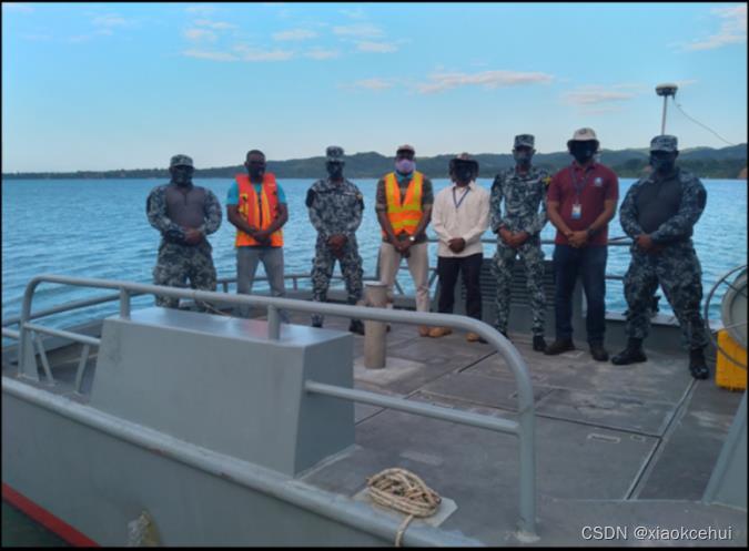
国家土地局于 2020 年 12 月对莫兰特港进行了单波束水深测量。调查目的是获取港口的水深数据,以更新第 275-3 号海图并满足其他水深需求。 调查覆盖面积约 3.4 平方公里(340 公顷)。 测线的间距为 20m,垂直于等深线布设。 为调查区生成了约171条开发线(计划线)和43条检查线。 调查进行了十多天,每天作业时间从06:00到18:00,见图1。
传统的单波束测量(SBSS)或多波束测量(MBSS)需要大量的人力和物力。如图2所示,有八人参与了项目的测量工作,包括牙买加国防军海岸警卫队提供的四名船员和国家土地局提供的四名测量员。
国家土地局和 TCarta Caribe合作
由于通过TCARTA可以很容易地取得卫星测深数据,鲍登港测量项目提供了一个验证卫星测深的可用性以提高水深测量效率的绝佳机会。 TCarta 团队希望测试卫星测深的潜力。 TCarta Caribe 向 国家土地局提供了鲍登港的 卫星测深数据。
TCarta 和国家土地局还合作举办了一个由TCARTA提出的能力建设研讨会,以实现三个目标:(1)卫星测深在水文调查规划方面的潜力;(2)卫星测深数据处理方法;(3)对鲍登港的单波束测深数据和卫星测深数据进行分析比较。
由于卫星测深软件已集成到 ArcGIS Pro 中的 ESRI 中,且国家土地局 已经使用 ArcGIS Pro,因此TCarta 团队认为国家土地局在此平台内构建其海洋空间数据基础设施是顺理成章的。
研讨会还讨论使用 TCarta 专有软件即ArcGIS Pro 中的多光谱测深工具 (MBT) 生成 卫星测深数据 的过程。同时,研讨会重点介绍了鲍登港卫星测深数据处理过程,并展望了在牙买加沿海水域使用卫星测深的可行性。最后,研讨会集中对单波束测深和卫星测深的数据进行对比统计分析。
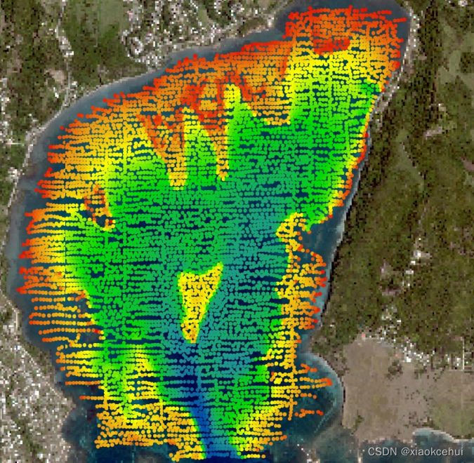
TCarta 将国家土地局的三条测线作为真值,校正卫星测深 数据,生成了海底地形图(见图 3)。图 4 根据卫星测深数据生成的,突出了计划测线的有效性和需要注意的绘制区。

图3 卫星测深融合单波束数据生成的地形图

图4 水深点和等深线。红色表示未测区,绿色表示浅点。
卫星测深数据 与单波束数据
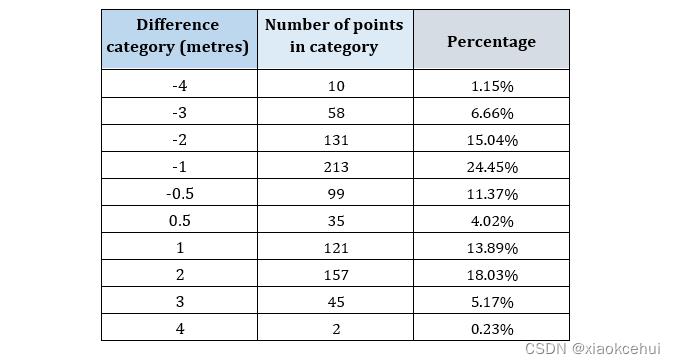
国家土地局 的 GIS 部门制作了单波束数据与卫星测深 数据的对比图。 在作图之前,TCarta调整卫星测深数据的 基准面为当地平均低潮面,大约比最低天文潮 高 0.25m。国家土地局 使用 ArcGIS 进行水深点比对,总共比对了871 组数据。 结果表明,15.39%的点相差±0.5m,86.80%的点相差±2米(见表1)。
基于对比图,对数据之间总体一致性进行分析,将水深差值叠加海底地形,确定不同深度范围内的特征(见图 5)。单波束水深数据和卫星测深数据之间的差值作为点的高程。 正值 (58.67%) 表明 卫星测深 数据较深,负值(41.33%) 表明 卫星测深数据比单波束 数据浅。
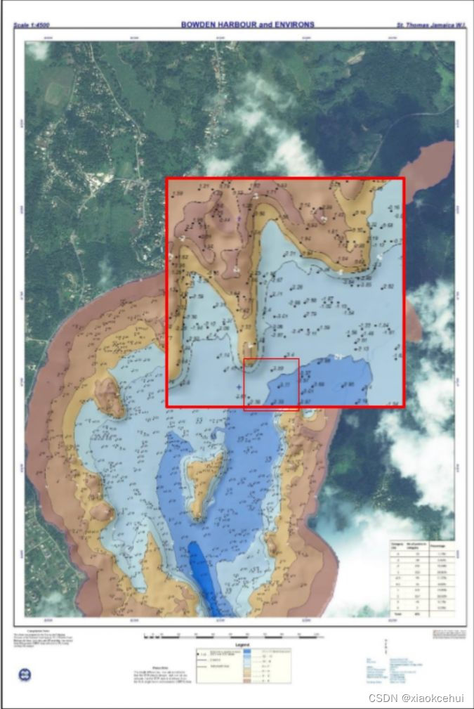
图5 单波束数据和卫星测深数据的比较:正值表示卫星测深数据较深,负值表示卫星测深数据比单波束数据浅。
国家土地局分析了10 个不同的地形区域。 总体趋势表明,与单波束测深数据相比,卫星测深数据在深水中更浅,在浅水中更深。
讨论
卫星测深技术大致指示了项目区域内的水深。 它逐渐检测到深度变化;换句话说,它“平滑”了深度的变化,探测不到露出水面的礁石。因此,卫星测深是填补空白的有用工具,不仅能填补单波束测线之间的空隙,而且能填补调查船无法测量的0m等深线以上区域,显著提高了水深数据的分辨率。 在海图数据不足的情况下,卫星测深数据是规划和进行传统水深测量可行性研究的极好工具。
卫星测深技术助推牙买加沿海水域测绘,这对蓝色经济至关重要,并有助于我们进一步了解气候变化和其他环境影响。该地区目前的重点是 2030海底倡议,该倡议旨在到 2030 年完成全球海底调查,因此该地区对测深数据的需求很大。当前疫情已经将有限的资源转移到了卫生部门,分配给海洋环境的资源必须尽可能有效地使用。一些国家减少调查团队的活动,以降低成本并减少新冠肺炎的传播。将卫星测深与传统调查方法相结合的协作方法有助于实现2030海底倡议。
卫星测深的集成有力地提高了时间效率、节约了成本和提高了安全性,有助于国家土地局水深测量规划发展。这种技术的协作和整合与 国家土地局的研发密切相关。
结论
卫星测深是一种快速且廉价的方式,可为渔业、灾后响应和救援计划等提供粗略水深,也可用作规划和进行传统水深测量可行性研究的工具,但在水深小于5m的地方,船舶仍应极其小心地航行。
Satellite-derived Bathymetry for Surveying Jamaica’s Coastal Waters
Towards Time Efficiencies, Cost savings and Improved Safety
By Carol Fisher, Antonio Williams • March 29, 2022
the national land agency in Jamaica has integrated satellite-based hydrography to benefit from time efficiencies, cost savings and improved safety as part of its hydrographic programme in support of the nation's further economic development.
Central America and the Caribbean region are blessed with beautiful coastal waters. However, most nations, if not all, face the arduous task of developing and managing their natural resources, such as the marine environment, while focusing on economic development. Under the International Convention for the Safety of Life at Sea (SOLAS), Jamaica is responsible for executing hydrographic surveys of its coastal waters. The National Land Agency (NLA), the recognized national hydrographic office, has a hydrographic survey programme in place to cover the bathymetry of Jamaica’s coastal waters in fulfilment of its responsibility to collect, maintain and disseminate nautical information to all its stakeholders. Through a contractual arrangement, Jamaica’s admiralty charts are produced and maintained by the United Kingdom Hydrographic Office (UKHO). The acquisition of refined, reliable and enhanced hydrographic information in Jamaica’s territorial waters supports Jamaica’s development as a nation, tapping further into the blue economy.
Background to the National Land Agency (NLA)
Under the Surveys and Mapping Division (SMD), the NLA is responsible for carrying out hydrographic surveys of Jamaica’s harbours and territorial waters. The NLA is the national hydrographic office recognized by the International Hydrographic Organization (IHO). While operating under resource constraints, as with most small island developing states, the SMD is tasked with surveying Jamaica’s coastal waters. Nonetheless, an intergovernmental agency partnership has been brokered through the National Hydrographic Committee (NHC), resulting in an agreement for the use of a Jamaica Defence Force Coast Guard vessel, which was utilized in the recent survey of Bowden Harbour in St. Thomas.
Port Morant (Bowden) Harbour Single Beam Sonar Bathymetric Survey
The NLA conducted a single beam hydrographic survey of Port Morant (Bowden) Harbour in December 2020. The purpose of the survey was to collect hydrographic data of the harbour to aid the update of Admiralty Chart number 275-3 and fulfil other hydrographic needs. The survey covered an area of approximately 3.4 square kilometres (340 hectares). The line spacing for the development lines was 20m, which ran perpendicular to the depth contours. Approximately 171 development lines (planned lines) and 43 check lines were generated for the survey area. The survey was carried out over ten days, collecting sonar data from 06:00 to 18:00.
A considerable amount of human and capital resources are required for the execution of a successful traditional single beam sonar survey (SBSS) or multibeam sonar survey (MBSS). As can be seen in Figure 2, eight people were involved in the data collection for this project. The Jamaica Defence Force Coast Guard provided four boat crew coxswain and boat aids, while the NLA provided four people as part of the data acquisition team.
Collaboration: National Land Agency and TCarta Caribe
The Bowden Harbour Project presented an excellent opportunity as a case study into the usefulness of satellite-derived bathymetry (SDB) to improve the efficiency of hydrographic surveys, as the SDB data was readily available through TCarta. Additionally, the team wanted to test the potential for SDB to support single beam surveys. TCarta Caribe provided the NLA with the SDB of Bowden Harbour to carry out the investigation.
TCarta and the NLA also teamed up after the survey for a capacity-building workshop, presented by TCarta, to address three objectives: (1) the SDB’s potential to inform hydrographic survey planning; (2) to describe/explain SDB production methods; and (3) to perform data analysis and comparisons between a single beam derived surface and that of the SDB for Bowden Harbour.
TCarta’s team advised that, as the SDB software is integrated into ESRI in ArcGIS Pro, and as the NLA already uses ArcGIS Pro, it would be a natural progression for the Carta’s NLA to build its marine spatial data infrastructure within this platform.
The workshop continued with a session on the process of producing SDB using TCarta proprietary software, the Multispectral Bathymetry Tool (MBT) in ArcGIS Pro. In addition, the workshop focused on the process involved in the production of SDB in Bowden Harbour and gave an overview of SDB’s feasibility in Jamaica’s coastal waters. The final session zeroed in on the statistical analysis of SDB in comparison to NLA single beam data.
TCarta used three NLA transect lines, as ground ‘truthing’, for the correction of the SDB data, from which a surface was produced (see Figure 3). A graphic representation of the SDB-derived data is shown in Figure 4, highlighting the usefulness of planning survey lines and mapping areas of caution.
TCarta SDB vs NLA SBES
The NLA’s GIS unit created a difference map of the single beam echo sounder (SBES) data versus the TCarta SDB data. Preceding the creation of the difference map, TCarta applied a datum adjustment to the SDB, adjusting the SDB depths to the local mean low water (MLW) datum, approximately 0.25m above lowest astronomical tide (LAT). A point-to-point comparison was carried out by the NLA’s team using ArcGIS, analysing 871 congruent points. The results show that 15.39% of the points had a difference of ±0.5m, while 86.80% had a difference within ±2 metres (see Table 1).
With the generation of the difference map, an analysis could be made of the general agreement between the data, cross-referencing these differences with the seafloor topology and identifying possible trends at various depth ranges (see Figure 5). The differences between the NLA SBES data and the TCarta SDB data are shown as spot heights. Positive (+) differences (58.67%) indicate that the SDB data is deeper and negative (–) differences (41.33%) indicate that the SDB data is shallower than the NLA SBES data.
NLA also analysed ten particular areas with varying seafloor topology. The general trend indicates that SDB data tends to be shallower in deeper water and deeper in shallow water, compared to NLA’s SBES data.
Discussion
The SDB technology was found to give a general indication of the depths within the project area. SDB gradually detects changes in depths; in other words, it ‘smooths’ the changes in depth and will not detect sudden outcrops or rocks. As such, SDB is a useful tool for filling in the gaps. These could be gaps between survey lines with respect to SBES or gaps in depths to the zero-depth contour, which are hard to survey with typical survey vessels, therefore improving on the spatial resolution. SDB is an excellent tool for planning and conducting feasibility studies of traditional bathymetric surveys to be undertaken, especially where inadequate chart data exists.
SDB technology can be a catalyst for the mapping of Jamaica’s coastal waters, which is vital to the blue economy and to further aid our understanding of climate change and other environmental impacts. With the current focus of the region on the Seabed 2030 initiative, which aims to survey the ocean floor by the year 2030, there is much demand for bathymetric data in the region. The current pandemic has seen already limited resources being diverted to the health sector, and those resources that are allocated to the marine environment must be used as efficiently as possible. Some countries have also seen the limited mobilization of hydrographic survey teams, to reduce costs as well as to reduce the spread of COVID-19. Collaborative approaches, such as the integration of SDB with traditional survey methods, is one approach that can aid the realization of the Seabed 2030 initiative.
The integration of satellite-based hydrography, which promotes time efficiencies, cost savings and improved safety, lends itself to the development of the NLA’s hydrographic programme. This collaboration and integration of technologies goes hand in hand with the NLA’s commitment to research and development.
Conclusion
SDB is a quick and inexpensive way to obtain a general idea of depths for applications such as fisheries and post-disaster response and rescue planning. It can be used as a tool for planning and conducting feasibility studies of traditional bathymetric surveys, but the vessel should navigate with the utmost care where the underkeel clearance is calculated to be less than five metres.
以上是关于基于卫星测深的牙买加沿岸水深测量的主要内容,如果未能解决你的问题,请参考以下文章