微信小程序 Notes | 开发常用事例
Posted HLQ_Struggle
tags:
篇首语:本文由小常识网(cha138.com)小编为大家整理,主要介绍了微信小程序 Notes | 开发常用事例相关的知识,希望对你有一定的参考价值。

前言
之前涉足小程序,简短的记录了下开发过程中遇到的点点滴滴:
而今再次负责小程序,时隔许久,真是一片懵逼,多亏了之前的简短记录,这里将会不断记录完善开发过程中遇到的一系列的小问题。
总是要不断努力,买车到现在,各种无奈,似乎国庆回来整个人都不好了,得赶紧调整了,不然梦想始终只是梦想了。
加油~
小事例汇总
对于不熟悉前端的 android 而言,前端是真的烦,说不清因为哪儿个属性就冲突了。相对比较好的一点是在线调试,调整参数样式,直接拷贝。什么时候 Android 也能有这样的神器就好了,哇咔咔,期待我 Android 越来越好~
1. 微信小程序如何构建 npm?
之前一直都是 Android 为主,突然在某个官网看到需要通过 npm 方式构建,顿时有点懵逼,这里记录下步骤,方便下次直接分分钟搞定~
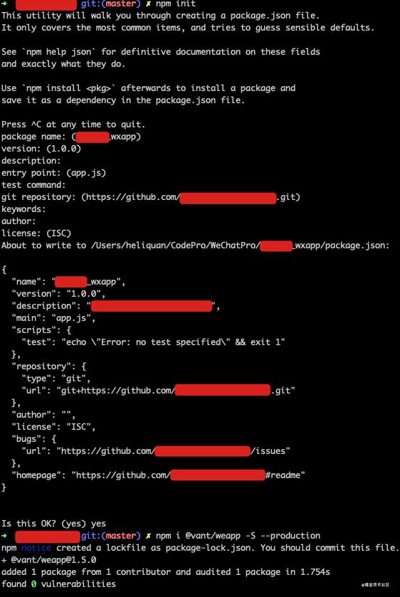
Step 1:进入小程序根目录执行 npm 初始化
- npm init
成功后会生成 package.json 文件。
Step 2:随后执行对应的 npm 安装依赖
例如这里需要使用有赞组件库 vant,所以对应的 npm 命令如下:
- npm i @vant/weapp -S --production
这两步对应的示意图如下:
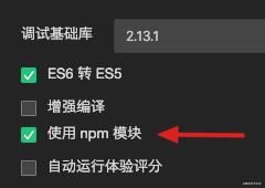
Step 3:在小程序开发工具中选择构建 npm。
这里需要注意一定在项目本地设置中打开 npm:
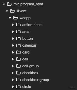
成功后会生成 miniprogram_npm 目录,里面变包含我们通过 npm 下载的 vant 代码了,如下:
2. 如何升级 npm 对应依赖包?
某天逛官网时挺懵逼的,看到人版本都提升几个了,无从下手,这里放上升级方式,其实和之前一毛一样,如下升级 vant 事例图:
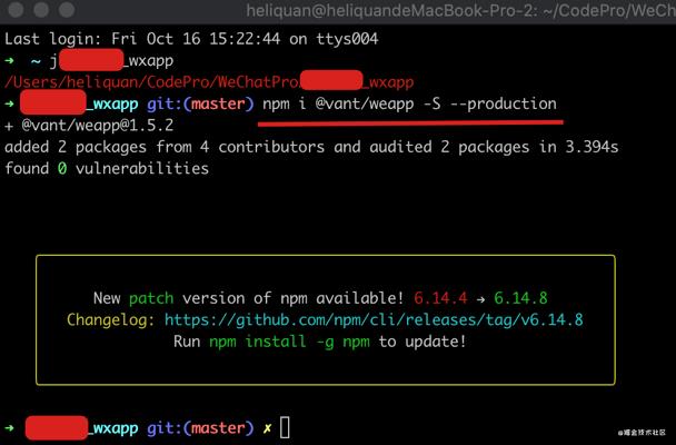
其实还是把官网提供的 npm 安装方式拷贝运行一次。
3. 如何点击 image 进入客服会话?
先附上效果图:
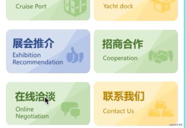
由于微信小程序 Api 中注明只有 button 才具有一些开放功能,而单独的 image 则无法实现点击跳转客服消息会话功能。前端个人感觉就是一个个元素通过不同的属性样式包罗万象,那么我能不能通过 button 包裹 image 间接实现这个效果呢?一起来看~
<view class="model">
  <button open-type="contact">
    <image mode="aspectFit" src="/images/img_07.png" />
  </button>
  <!-- ... -->
</view>
样式文件如下:
.model
  display: flex;
  justify-content: space-between;
  margin-top: 30rpx;


.model button
  height: 180rpx;
  width: 49%;
  background-color: transparent !important;
  margin: 0;
  padding: 0 !important;


.model button::after
  border: 0px solid rgba(0, 0, 0, 0.2) !important;


.content .model button image
  width: 100%;
4. 如何打开/预览云平台 PDF?
先来看下粗略的效果图:
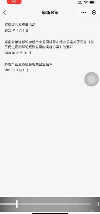
大概是有那么点意思:
- 支持打开/预览在线 PDF;
- 支持显示 PDF 原有名称;
- 支持分享、收藏。
其实还是下载本地,然后打开,高大上忽悠就是支持预览在线 PDF,😂
先来看下我本地模拟的基础数据:
newsList: [
        newID: 0,
        title: '最新活动',
        content: '游艇xx活动',
        pdfUrl: urlUtils.getDownloadPDFUrl('/pdf/xxn.pdf'),
        createTime: '2020 年 4 月 1 日'
      ,

        newID: 1,
        title: '产业政策',
        content: '海南省xxx通知',
        pdfUrl: urlUtils.getDownloadPDFUrl('/pdf/xx.pdf'),
        createTime: '2019 年 12 月 30 日'
      ,

        newID: 2,
        title: '最新内容',
        content: '游艇xx名单',
        pdfUrl: urlUtils.getDownloadPDFUrl('/pdf/xx.pdf'),
        createTime: '2020 年 4 月 1 日'

    ],
随后附上关键代码:
/**
 * 加载 PDF 文档
 */
onLoadItemPDF: function(event)
  wx.showLoading(
    title: '文件缓冲中...',
  )
  var itemId = parseInt(event.currentTarget.dataset.newsid);
  var saveTempFilePath = wx.env.USER_DATA_PATH + '/temp.pdf';
  var newFilePath = wx.env.USER_DATA_PATH + '/' + this.data.newsList[itemId].content + '.pdf';
  wx.downloadFile(
    url: this.data.newsList[itemId].pdfUrl,
    filePath: saveTempFilePath,
    success: function(res)
      if (res.statusCode == 200)
        var fileSystemManager = wx.getFileSystemManager();
        fileSystemManager.rename(
          oldPath: saveTempFilePath,
          newPath: newFilePath,
          success: function(res)
            wx.openDocument(
              filePath: newFilePath,
              fileType: 'pdf',
              showMenu: 'true',
              success: function(res)
                console.log("----> 打开文档成功 ");
                wx.hideLoading()
              ,
              fail: function(res)
                console.log("----> 打开文档失败 ");
                console.log(res);
                wx.hideLoading()
                wx.showToast(
                  title: '文档打开失败,请稍后再试!',
                  icon: 'none'
                )

            )
          ,
          fail: function(res)
            console.log("----> 重命名文档失败 " + res);
            wx.hideLoading()
            wx.showToast(
              title: '重命名文档失败,请稍后再试!',
              icon: 'none'
            )

        );

    ,
    fail: function(res)
      console.log(res);
      wx.hideLoading()
      wx.showToast(
        title: '文档打开失败,请稍后再试!',
        icon: 'none'
      )

  )
,
代码较为简单,这里就不一一细说了。细心的小伙伴观察到这里在下载完成后使用了重命名,主要是为了避免打开 PDF 时标题为临时字符,如下所示:

这段代码其实还不是狠完善,最起码提示这块,可以单独封装一层,这里就偷个懒了先。
哦,对,还有一点,云平台 PDF 地址记得拷贝下载地址哈!
5. 改造 vant-tabs 实现放大/缩小 tab 切换
先来看个效果吧,Android 那边现成的 TabLayout 及其方便快捷,到了这边,哎。
怪我,不懂前端。
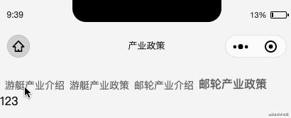
没啥说的,基于 vant-tabs 改造即可,下面直接附上完整代码。
<van-tabs active=" active " animated swipeable nav-class="nav-class" tab-class="tab-class" tab-active-class="tab-active-class">

  <van-tab title="游艇产业介绍">
    123
  </van-tab>

  <van-tab title="游艇产业政策">
    123
  </van-tab>

  <!-- ... -->

</van-tabs>
样式文件如下:
.van-ellipsis
  margin: 6rpx 0rpx 6rpx 14rpx;


.tab-class
  display: contents !important;
  padding: 0 12px !important;
  color: var(--tab-text-color, #646566) !important;
  font-size: var(--tab-font-size, 14px) !important;
  line-height: var(--tabs-line-height, 112rpx) !important;


.tab-active-class
  font-weight: var(--font-weight-bold, 800);
  font-size: var(--tab-font-size, 16px) !important;
  color: var(--tab-active-text-color, #323233);
  line-height: 105rpx !important;


.nav-class
  height: auto !important;
  background-color: #f5f5f5;
除了第一个样式比较特殊,剩下都是按照官方提供的自定义样式而来,这里简单截图说明下,便于日后查看:

6. 如何实现 tabs 内容高度充满屏幕?
要在 tabs 中嵌套一个地图,按道理来讲设置宽高 100% 就应该是充满屏幕了,结果是这个惨样子:
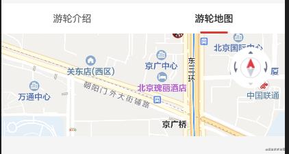
下面还是空余了很大的空间,突然想到之前 php 使用过的 vh,据说是动态屏幕大小,调整后如下:
map
  width: 100%;
  height: 94.5vh;
这样就能充满整个屏幕咯。小伙伴可以想想为什么不设置 100vh?
7. 如何实现 text 最多显示两行,超出 … 显示?

样式如下:
.item_action_title
  display: -webkit-box;
  -webkit-box-orient: vertical;
  -webkit-line-clamp: 2;
  overflow: hidden;
  text-overflow: ellipsis;
  text-overflow: -o-ellipsis-lastline;
8. 如何在 map 上添加对应浮层?
先来看下最终的效果:
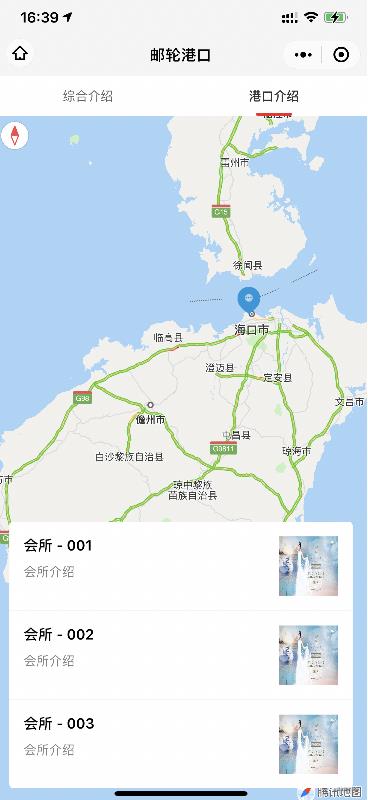
这里 diss 下微信小程序官方神逻辑,明明我在模拟器一通操作猛如虎,为何运行真机不显示?逗我玩呢?为什么不直接在模拟器上禁止呢?好玩吗?
先说几点注意事项吧:
- map 组件是由客户端创建的原生组件,它的层级是最高的 (也就是说不支持在 map 上使用常规方式添加内容);
- cover-view 只支持嵌套 cover-view、cover-image,可在 cover-view 中使用 button。组件属性的长度单位默认为 px,2.4.0 起支持传入单位(rpx/px);
- cover-image 直到现在(2020-10-23)不支持 mode,图片缩放模式。
首先来看下我这里简单模拟的数据格式:
portList: [
      title: '会所 - 001',
      desc: '会所介绍',
      avatar: 'http://www.china-rendezvous.com/Index/Tpl/Public/images/index/banner.jpg'
    ,
      title: '会所 - 002',
      desc: '会所介绍',
      avatar: 'http://www.china-rendezvous.com/Index/Tpl/Public/images/index/banner.jpg'
    ,
      title: '会所 - 003',
      desc: '会所介绍',
      avatar: 'http://www.china-rendezvous.com/Index/Tpl/Public/images/index/banner.jpg'
    , ]
随后附上 map 关键代码:
<map setting=" setting ">
  <cover-view class="port_class">
    <block wx:for=" portList " wx:key="port">
      <cover-view class="item_port">
        <cover-view class="item_port_content">
          <cover-view class="title"> item.title </cover-view>
          <cover-view class="desc"> item.desc </cover-view>
        </cover-view>
        <cover-image src=" item.avatar " />
      </cover-view>
      <cover-view class="divider_line" wx:if=" index < portList.length - 1 " />
    </block>
  </cover-view>
</map>
对应 js:
// 地图基本配置
setting:
  skew: 0, // 倾斜角度
  rotate: 0, // 旋转叫丢
  scale: 8, // 缩放级别,取值范围为3-20
  showLocation: true, // 显示带有方向的当前定位点
  showScale: true, // 显示比例尺
  subKey: '', // 个性化地图使用的key
  layerStyle: 1, // 个性化地图配置的 style,不支持动态修改
  longitude: 109.76685421005249,
  latitude: 19.207716690636587,
  enableZoom: true, // 是否支持缩放
  enableScroll: true, // 是否支持拖动
  enableRotate: true, // 是否支持旋转
  showCompass: true, // 显示指南针
  enable3D: false, // 展示3D楼块
  enableOverlooking: true, // 开启俯视
  enableSatellite: false, // 是否开启卫星图
  enableTraffic: true, // 是否开启实时路况
  markers: [
    iconPath: "/images/img_position_flag.png",
    id: 0,
    latitude: 20.045611,
    longitude: 110.181885,
    width: 30,
    height: 30
  , ],
,
最后的 css 样式文件:
map
  width: 100%;
  height: 94.5vh;


.port_class
  display: flex;
  flex-direction: column;
  margin: 30rpx;
  background: #fff;
  border-radius: 8rpx;
  position: absolute;
  bottom: 0;
  left: 0;
  right: 0;
  max-height: 45vh;


.port_class .item_port
  display: flex;
  flex-direction: rows;
  padding: 30rpx;
  justify-content: space-between;


.port_class .item_port .item_port_content
  display: flex;
  flex-direction: column;
  flex: 1;


.port_class .item_port .item_port_content .title
  font-size: 30rpx;
  font-weight: bold;


.port_class .item_port .item_port_content .desc
  font-size: 26rpx;
  color: gray;
  margin-top: 22rpx;
  display: -webkit-box;
  -webkit-box-orient: vertical;
  -webkit-line-clamp: 2;
  overflow: hidden;
  text-overflow: ellipsis;
  text-overflow: -o-ellipsis-lastline;


.port_class .item_port cover-image
  height: 120rpx;
  width: 120rpx;
  margin-left: 30rpx;


.port_class .divider_line
  background-color: #f5f5f5;
  width: 100%;
  height: 3rpx;
9. 如何实现 map 平移 markers?
记得添加权限,详情查看文末异常汇总。
来看下效果图:
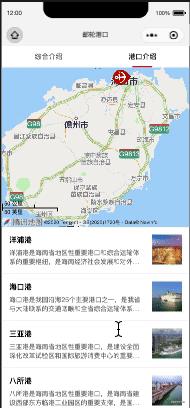
这里附上关键 js 代码:
/**
 * 生命周期函数--监听页面初次渲染完成
 */
onReady: function()
  this.mapContext = wx.createMapContext('map');
,

/**
 * 港口 item 点击 - 地图 markers 平移
 */
onPortItemClick: function(event)
  let that = this;
  let currentId = event.currentTarget.dataset.portid;
  // 获取 markers 目标经纬度
  let destination =
    longitude: that.data.portList[currentId].longitude,
    latitude: that.data.portList[currentId].latitude
  ;
  // 平移 markers
  this.mapContext.translateMarker(
    markerId: 0,
    destination: destination,
    autoRotate: true,
    rotate: 0,
    duration: 1000,
    success(res)
      console.log('---> 平移成功 ', res)
    ,
    fail(err)
      console.log('---> 平移失败 ', err)

  );
哦,对了,html 文件如下:
<map id="map" setting=" setting " />
10. 如何平移 markers 到地图中心?
记得添加权限,详情查看文末异常汇总。
先来看下效果图:
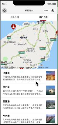
html 文件如下:
<map id="map" setting=" setting " show-location />
关键 js 代码如下:
/**
 * 港口 item 点击 - 地图 markers 平移
 */
onPortItemClick: function(event)
  let that = this;
  let currentId = event.currentTarget.dataset.portid;
  // 平移 markers 到地图中心
  this.mapContext.moveToLocation(
    longitude: that.data.portList[currentId].longitude,
    latitude: that.data.portList[currentId].latitude,
    success(res)
      console.log('---> 平移成功 ', res)
    ,
    fail(err)
      console.log('---> 平移失败 ', err)

  );
11. 关于标题设置静态/动态
一般而言,对于某些固定的页面,我会直接在页面对应的 json 文件指定:
"navigationBarTitleText": "详情",
而某些动态,则通过如下方式进行动态设置:
// 设置标题
wx.setNavigationBarTitle(
  title: portBean.title,
);
12. 关于获取用户公开信息
我这里用的是 vant-button 和 button 没啥区别,内容如下:
<van-button
    wx:if=" avatarUrl "
    open-type="getUserInfo"
    bindgetuserinfo="bindGetUserInfo"
    color="#1497da"
    custom-class="login" round type="info">登录/注册</van-button>
对应的 js:
/**
 * 生命周期函数--监听页面加载
 */
onLoad: function(options)
  wx.getSetting(
    success: function(res)
      if (res.authSetting['scope.userInfo'])
        wx.getUserInfo(
          success: function(res)
            console.log(res);

        )


  )
,

/**
 * 获取用户信息
 */
bindGetUserInfo: function(res)
  console.log(res);
,
获取到的数据:
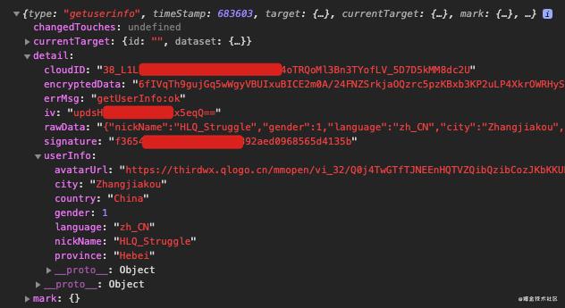
首次会弹个框,如下:

13. 如何在地图上绘制覆盖物?
先来看下效果:

再来看一波官方 Api:

附上 wxml 代码:
<map id="map" setting=" setting " scale="15" show-location polygons="polygons" />
以及对应的 js 文件:
首先我们定义一个存放坐标点的 list:
const mTempWaterPolygonsList = [
  points: [
      longitude: 110.2100,
      latitude: 20.0449
    ,

      longitude: 110.2100,
      latitude: 20.0651
    ,

      longitude: 110.3100,
      latitude: 20.0653
    ,

      longitude: 110.3101,
      latitude: 20.0104
    ,
  ],
  strokeColor: "#333",
  strokeWidth: 3,
  fillColor: "#80333333"
,
  points: [
      longitude: 110.4036,
      latitude: 19.1908
    ,

      longitude: 110.4300,
      latitude: 19.1759
    ,

      longitude: 110.3457,
      latitude: 19.0230
    ,

      longitude: 110.3401,
      latitude: 19.0246
    ,
  ],
  strokeColor: "#333",
  strokeWidth: 3,
  fillColor: "#80333333"
, ];
初始化 map 基本设置:
data:
  // 地图基本配置
  setting:
    skew: 0, // 倾斜角度
    rotate: 0, // 旋转角度
    scale: 11, // 缩放级别,取值范围为3-20
    showLocation: true, // 显示带有方向的当前定位点
    showScale: true, // 显示比例尺
    subKey: '', // 个性化地图使用的key
    layerStyle: 1, // 个性化地图配置的 style,不支持动态修改
    longitude: 110.260025,
    latitude: 20.046425,
    enableZoom: true, // 是否支持缩放
    enableScroll: true, // 是否支持拖动
    enableRotate: true, // 是否支持旋转
    showCompass: true, // 显示指南针
    enable3D: false, // 展示3D楼块
    enableOverlooking: true, // 开启俯视
    enableSatellite: false, // 是否开启卫星图
    enableTraffic: false, // 是否开启实时路况
  ,
  // 默认绘制第一个覆盖物
  polygons: [
    ...mTempWaterPolygonsList[0]
  , ],
,
而关于点击绘制其它覆盖物时,只需要动态更新 polygons 即可,例如我这里的操作:
/**
 * item click
 * Step 1: 平移中心点到地图中心;
 * Step 2: 绘制点对应覆盖物
 */
onWaterItemClick: function(event)
  let that = this;
  let currentId = event.currentTarget.dataset.waterid;
  // Step 1: 平移中心点到地图中心;
  this.mapContext.moveToLocation(
    longitude: that.data.tempWaterList[currentId].centerLongitude,
    latitude: that.data.tempWaterList[currentId].centerLatitude,
    success(res)
      console.log('---> 平移成功 ', res)
    ,
    fail(err)
      console.log('---> 平移失败 ', err)

  );
  // Step 2: 绘制点对应覆盖物
  let polygons = mTempWaterPolygonsList[currentId];
  that.setData(
    'polygons[0]': polygons,
  );
,
End
十多条整理下来,也是一段小经历。
微薄之力,助力和我一样小白~
一起加油~
万一不小心优秀了呢?
异常汇总
- oveToMapLocation:fail require permission desc
官方说明:获取用户位置信息时需填写用途说明
在 app.json 中添加获取位置权限:
"permission":
  "scope.userLocation":
    "desc": "您的位置信息将用于小程序地图的效果展示"

,
参考资料
以上是关于微信小程序 Notes | 开发常用事例的主要内容,如果未能解决你的问题,请参考以下文章