ArcGIS API for js InfoWindow
Posted 学习靠自己
tags:
篇首语:本文由小常识网(cha138.com)小编为大家整理,主要介绍了ArcGIS API for js InfoWindow相关的知识,希望对你有一定的参考价值。
说明:有关该示例中怎么引用部署在iis上的离线arcgis api请参考我前面的博文
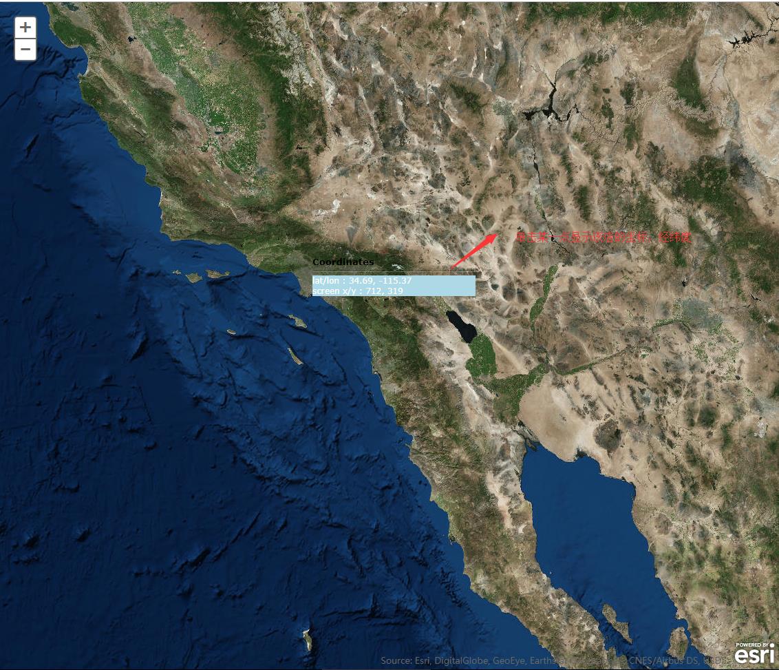
1、运行效果

2、html代码
<!DOCTYPE html>
<html>
  <head>
    <meta http-equiv="Content-Type" content="text/html; charset=utf-8">

    <meta name="viewport" content="initial-scale=1, maximum-scale=1,user-scalable=no">
    <title>Non graphic info window</title>

<link rel="stylesheet" type="text/css" href="http://localhost/arcgis_js_api/library/3.3/jsapi/js/esri/css/esri.css" />
    <style>
      html, body, #map{
        height: 100%;
        margin: 0;
        padding: 0;
      }

        .esriPopup .titlePane
        {
             background-color: rgba(64,64,64,0.8);

        }
        .esriPopup .contentPane
        {
             background-color: rgba(64,64,64,0.8);
             color: #FFFFFF;
        }
        .esriPopup .actionsPane
        {
          background-color: rgba(64,64,64,0.8);
        }
    </style>

    <script type="text/javascript" src="http://localhost/arcgis_js_api/library/3.3/jsapi/init.js"></script>
    <script>
        var map;
        require([
            "esri/map"

        ], function (
            Map
          ) {
            map = new esri.Map("map", {
                basemap: "satellite",
                center: [-116.96, 33.184],
                zoom: 7
            });

            map.on("load", function () {
                map.infoWindow.resize(250, 100);
            });

            map.on("click", addPoint);

            function addPoint(evt) {
                var latitude = evt.mapPoint.getLatitude();
                var longitude = evt.mapPoint.getLongitude();
                map.infoWindow.setTitle("Coordinates");
                map.infoWindow.setContent(
                    \'<div style="background-color:lightblue;color:white;">\' +
                  "lat/lon : " + latitude.toFixed(2) + ", " + longitude.toFixed(2) +
                  "<br>screen x/y : " + evt.screenPoint.x + ", " + evt.screenPoint.y+\'</div>\'
                );
                map.infoWindow.show(evt.mapPoint, map.getInfoWindowAnchor(evt.screenPoint));
            }
        });

    </script>
  </head>
  <body>
    <div id="map"></div>
  </body>
</html>
其中的代码
   map = new esri.Map("map", {
                basemap: "satellite",
                center: [-116.96, 33.184],
                zoom: 7
            });
也可以替换为下面的形式:
map = new esri.Map("map", { center: [-116.96, 33.184], zoom: 4 });
MyTiledMapServiceLayer = new esri.layers.ArcGISTiledMapServiceLayer
("http://localhost/arcgis/rest/services/DZDT2012/MapServer");
map.addLayer(MyTiledMapServiceLayer);
以上是关于ArcGIS API for js InfoWindow的主要内容,如果未能解决你的问题,请参考以下文章