GeoTools的AStar算法实现,自定义Node及Edge
Posted 爱是与世界平行
tags:
篇首语:本文由小常识网(cha138.com)小编为大家整理,主要介绍了GeoTools的AStar算法实现,自定义Node及Edge相关的知识,希望对你有一定的参考价值。
1 核心依赖包
开发语言java
<dependency>
    <groupId>org.geotools</groupId>
    <artifactId>gt-graph</artifactId>
    <version>18.0</version>
</dependency>
Geotools提供了一个Graph的扩展包,这个扩展包不只是对A*算法进行了实现,也对算法Dijkstra进行了实现,两种算法在Geotools中的用法基本一致。
2 基本概念介绍

2.1 Graph(图)
可以理解为是一个将要建模的对象的容器,图里面存放的是很多的点(node)和边(edge)。
2.2 Node(点)
Node(点)是将要建模的对象,它可以指的是实际地图中的一个坐标点,也可以指的是任意坐标系中的一个点,也可以指的是拓扑图里面的一个节点。构建好的Node全部都存放在Graph中。
2.3 Edge(边)
边是指两个Node(点)的关联,一个边下面会有两个点,在图中的边是认为两个点之间可到达,边下面两个点分别表示NodeA和NodeB,节点方向为NodeA->NodeB,
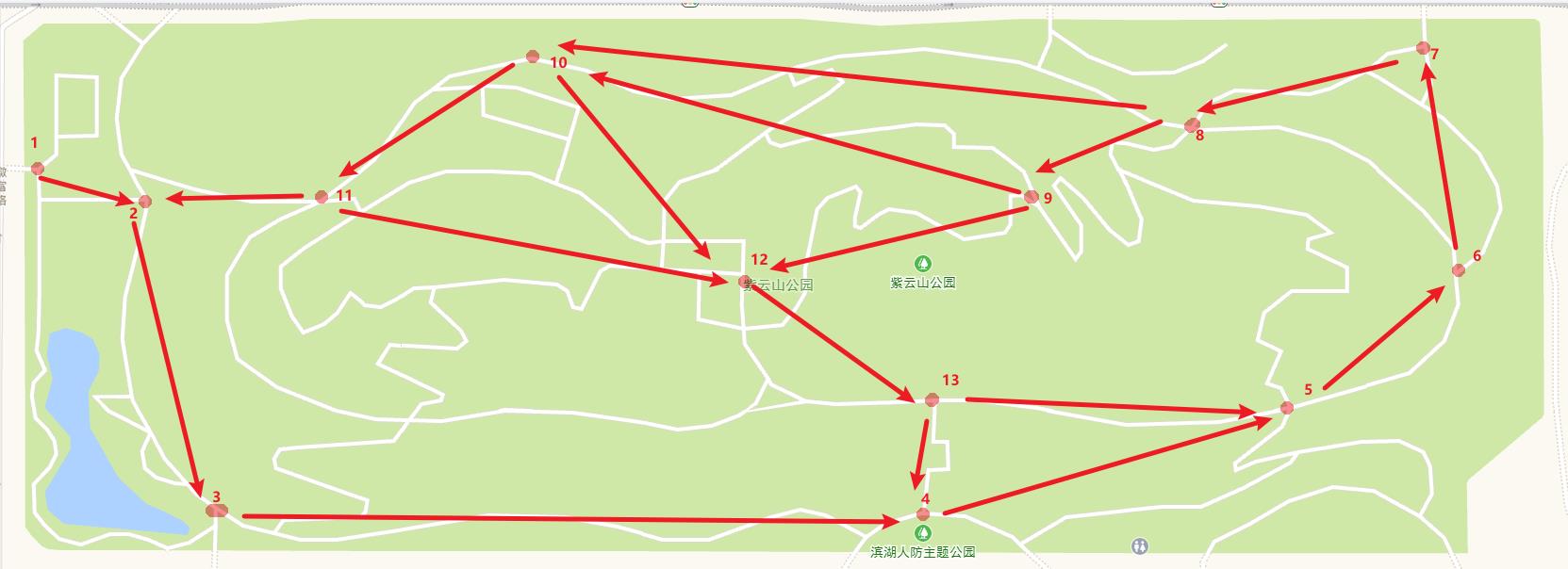
3 在地图上标注POI点,并采集每个点的坐标
如图,合肥紫云山公园(随便选的公园),随意标注13个POI点(随便标注的点),采集这13个点的坐标。

坐标采集可以通过百度、或者高德的坐标采集器实现。
如高德坐标采集器地址:高德地图获取地图坐标(GCJ-02坐标) - openGPS.cn
定位到该公园:117.329088,31.739236
获取到13个点的坐标。
4 标注出13个POI的拓扑关系,即到达关系
如图,标注出每个POI的拓扑关系(随便标注的)
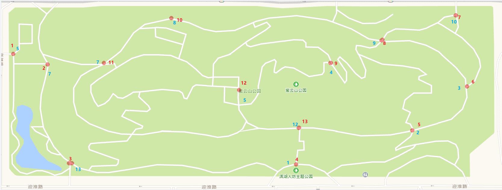
5 生成Node节点以及Edge边,并标注POI点与Node节点对应关系
Node生成出来是无序的,如图所示(需根据生成的Node节点和POI点进行对应)。
//构造点
BasicGraphGenerator basicGraphGenerator = new BasicGraphGenerator();
BasicGraphBuilder basicGraphBuilder = new BasicGraphBuilder();
Coordinate[] coordinates = new Coordinate[12];
coordinates[0] = new Coordinate(104.069649, 30.542246);
coordinates[1] = new Coordinate(104.071001, 30.542283);
coordinates[2] = new Coordinate(104.073458, 30.542329);
.....................
List<Node> nodeList = new ArrayList<>();
for (int i = 0; i < 12; i++)
    Node node = basicGraphGenerator.getGraphBuilder().buildNode();
    basicGraphGenerator.getGraphBuilder().addNode(node);
    node.setObject(coordinates[i]);
    node.setID(i);
    node.setCount(i);
    node.setVisited(true);
    basicGraphBuilder.addNode(node);
    nodeList.add(node);
Node生成示例数据如下:V=[6, 9, 1, 7, 4, 2, 8, 10, 5, 11, 3, 0]
Edge生成:
public static Graph buildEdge(BasicGraphBuilder basicGraphBuilder, List<Node> nodeList)
    BasicGraphGenerator basicGraphGenerator = new BasicGraphGenerator();
    Map<Integer, String> map = new HashMap<>();
    //维护Edge关系
    map.put(1, "2");
    map.put(2, "3,12");
    map.put(3, "4,10");
    map.put(4, "5");
    map.put(5, "6");
    map.put(6, "7,11");
    map.put(7, "8");
    map.put(8, "1");
    map.put(9, "4");
    map.put(10, "9,11");
    map.put(11, "12,7");
    map.put(12, "7");
    for (Map.Entry<Integer, String> entry : map.entrySet())
        if (entry.getValue().split(",").length > 1)
            String[] strings = entry.getValue().split(",");
            for (String string : strings)
                //判断nodeList数组越界情况
                if (Integer.parseInt(string) == 12)
                    string = "11";

                Edge edge = new BasicEdge(nodeList.get(entry.getKey()), nodeList.get(Integer.parseInt(string)));
                Long distance = getDistance(nodeList.get(entry.getKey()), nodeList.get(Integer.parseInt(string)));
                edge.setObject(distance);
                edge.setVisited(true);
                basicGraphBuilder.addEdge(edge);

         else
            Integer key = entry.getKey();
            //判断nodeList数组越界情况
            if (Integer.parseInt(entry.getValue()) == 12)
                entry.setValue("11");

            //判断nodeList数组越界情况
            if (key == 12)
                key = 11;

            //构造边
            Edge edge = new BasicEdge(nodeList.get(key), nodeList.get(Integer.parseInt(entry.getValue())));
            Long distance = getDistance(nodeList.get(key), nodeList.get(Integer.parseInt(entry.getValue())));
            edge.setObject(distance);
            edge.setVisited(true);
            basicGraphBuilder.addEdge(edge);


    System.out.println(basicGraphBuilder.getNodes());
    System.out.println(basicGraphBuilder.getGraph());
    return basicGraphBuilder.getGraph();
Edge生成示例数据如下:
E=[13 (2,3), 25 (10,11), 14 (2,11), 16 (3,10), 18 (5,6), 17 (4,5), 15 (3,4), 24 (10,9), 22 (8,1), 19 (6,7), 23 (9,4), 21 (7,8), 28 (11,7), 20 (6,11), 26 (11,11), 12 (1,2), 27 (11,7)]
注意,Edge括号中,描述的为POI点的序号。
标注Edge的关系,示例如图。

6 使用AStar导航进行计算路径
public static void AStarShortestPath(Graph graph, Node startNode, Node endNode)
        AStarIterator.AStarFunctions aStarFunction = new AStarIterator.AStarFunctions(endNode)
            @Override
            public double cost(AStarIterator.AStarNode aStarNode, AStarIterator.AStarNode aStarNode1)
                Edge edge = aStarNode.getNode().getEdge(aStarNode1.getNode());
                System.out.println("edge=" + edge.getID() + ",Distance" + edge.getObject());
                /*SimpleFeature feature = (SimpleFeature) edge.getObject();
                Geometry geometry = (Geometry) feature.getDefaultGeometry();
                System.out.println(aStarNode.getH());
                return geometry.getLength();*/
//                return Integer.parseInt(String.valueOf(edge.getObject()));
                return 10;


            @Override
            public double h(Node node)
                return -10;

        ;
        Date start = new Date();
        AStarShortestPathFinder aStarPf = new AStarShortestPathFinder(graph, startNode, endNode, aStarFunction);
        try
            aStarPf.calculate();
            Date end = new Date();
            System.out.println("AStar算法耗时:" + (end.getTime() - start.getTime()));
            aStarPf.getPath();
            System.out.println("AStar算法距离:" + getPathLength(aStarPf.getPath()));
/*            Iterator it = aStarPf.getPath().iterator();
            String result = "";
            while (it.hasNext())
                Node node = (Node) it.next();
                result = result + node.getObject().toString();

            System.out.println("result:" + result);*/
         catch (Exception e)
            e.printStackTrace();
7 完整代码
import org.geotools.data.DataStore;
import org.geotools.data.shapefile.ShapefileDataStore;
import org.geotools.data.simple.SimpleFeatureCollection;
import org.geotools.feature.FeatureIterator;
import org.geotools.graph.build.basic.BasicGraphBuilder;
import org.geotools.graph.build.basic.BasicGraphGenerator;
import org.geotools.graph.build.feature.FeatureGraphGenerator;
import org.geotools.graph.build.line.LineStringGraphGenerator;
import org.geotools.graph.path.AStarShortestPathFinder;
import org.geotools.graph.path.Path;
import org.geotools.graph.structure.Edge;
import org.geotools.graph.structure.Graph;
import org.geotools.graph.structure.Node;
import org.geotools.graph.structure.basic.BasicEdge;
import org.geotools.graph.traverse.standard.AStarIterator;
import org.geotools.referencing.GeodeticCalculator;
import org.geotools.referencing.crs.DefaultGeographicCRS;
import org.locationtech.jts.geom.Coordinate;
import org.opengis.feature.Feature;

import java.io.File;
import java.io.IOException;
import java.net.MalformedURLException;
import java.util.*;

public class NavigationUtil

    /*public static void main(String[] args) throws IOException

        File file = new File("E:\\\\公交路线.shp");
        //1.读取shp数据
        DataStore dataStore = readShapeFile(file);
        SimpleFeatureSource featureSource = dataStore.getFeatureSource(dataStore.getTypeNames()[0]);
        SimpleFeatureCollection simFeatureCollect = featureSource.getFeatures();
        System.out.println("shp文件原始线的个数:" + simFeatureCollect.size());
        //2.创建graph数据结构
        Graph graph = buildGraph(simFeatureCollect);
        Iterator<Node> iterator = graph.getNodes().iterator();
        List<Node> nodeArrayList = new ArrayList<>();
        while (iterator.hasNext())
            nodeArrayList.add(iterator.next());

        System.out.println("节点:" + graph.getNodes());
        System.out.println("边:" + graph.getEdges());
        System.out.println(nodeArrayList.get(74));
        System.out.println(nodeArrayList.get(283));
        AStarShortestPath(graph, nodeArrayList.get(74), nodeArrayList.get(283));
    */

    public static void main(String[] args) throws IOException
        buildNodeAndEdgeGraph();


    public static void AStarShortestPath(Graph graph, Node startNode, Node endNode)
        AStarIterator.AStarFunctions aStarFunction = new AStarIterator.AStarFunctions(endNode)
            @Override
            public double cost(AStarIterator.AStarNode aStarNode, AStarIterator.AStarNode aStarNode1)
                Edge edge = aStarNode.getNode().getEdge(aStarNode1.getNode());
                System.out.println("edge=" + edge.getID() + ",Distance" + edge.getObject());
                /*SimpleFeature feature = (SimpleFeature) edge.getObject();
                Geometry geometry = (Geometry) feature.getDefaultGeometry();
                System.out.println(aStarNode.getH());
                return geometry.getLength();*/
//                return Integer.parseInt(String.valueOf(edge.getObject()));
                return 10;


            @Override
            public double h(Node node)
                return -10;

        ;
        Date start = new Date();
        AStarShortestPathFinder aStarPf = new AStarShortestPathFinder(graph, startNode, endNode, aStarFunction);
        try
            aStarPf.calculate();
            Date end = new Date();
            System.out.println("AStar算法耗时:" + (end.getTime() - start.getTime()));
            aStarPf.getPath();
            System.out.println("AStar算法距离:" + getPathLength(aStarPf.getPath()));
/*            Iterator it = aStarPf.getPath().iterator();
            String result = "";
            while (it.hasNext())
                Node node = (Node) it.next();
                result = result + node.getObject().toString();

            System.out.println("result:" + result);*/
         catch (Exception e)
            e.printStackTrace();


    public static DataStore readShapeFile(File shpFile) throws MalformedURLException
        ShapefileDataStore shapefileDataStore = new ShapefileDataStore(shpFile.toURI().toURL());
        return shapefileDataStore;


    public static Graph buildNodeAndEdgeGraph()
        //构造点
        BasicGraphGenerator basicGraphGenerator = new BasicGraphGenerator();
        BasicGraphBuilder basicGraphBuilder = new BasicGraphBuilder();
        Coordinate[] coordinates = new Coordinate[12];
        coordinates[0] = new Coordinate(104.069649, 30.542246);
        coordinates[1] = new Coordinate(104.071001, 30.542283);
        //此处省略好多点,麻烦自己手动采集
        List<Node> nodeList = new ArrayList<>();
        for (int i = 0; i < 12; i++)
            Node node = basicGraphGenerator.getGraphBuilder().buildNode();
            basicGraphGenerator.getGraphBuilder().addNode(node);
            node.setObject(coordinates[i]);
            node.setID(i);
            node.setCount(i);
            node.setVisited(true);
            basicGraphBuilder.addNode(node);
            nodeList.add(node);

        buildEdge(basicGraphBuilder, nodeList);
        System.out.println("nodeList:" + nodeList);
        AStarSh以上是关于GeoTools的AStar算法实现,自定义Node及Edge的主要内容,如果未能解决你的问题,请参考以下文章