Android——高德地图实现多点连线与点击定位监听实现
Posted 化作孤岛的瓜
tags:
篇首语:本文由小常识网(cha138.com)小编为大家整理,主要介绍了Android——高德地图实现多点连线与点击定位监听实现相关的知识,希望对你有一定的参考价值。
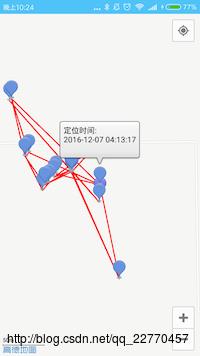
最近开发的项目中需要使用到的功能,如下图所示:

服务器会传来一个包含项数据类型为坐标与时间的数组。
需要实现的功能有:
1.按时间顺序对每个点进行连线。
2.点击单个点会在点的上分dialog内显示时间(如下图)。

3.初始化定位至第一个点处。
代码实现:
1.按时间顺序对每个点进行连线。
思路:先服务器回传的ArrayList进行按时间排序:
  //按时间对结果集进行排序
        Collections.sort(msgInfo.getPageList(), new SortByTime());
        List<LatLng> latLngs = new ArrayList<LatLng>();
        for (MsgInfo.MsgBody body : msgInfo.getPageList())
            //添加点集合
            drawPoint(body.getLat(), body.getLng(), DateUtils.dateFormat(body.getDate().longValue() * 1000));
            //添加线集合
            latLngs.add(new LatLng(body.getLat(), body.getLng()));
            polyline = aMap.addPolyline(new PolylineOptions().
                    addAll(latLngs).width(5).color(Color.argb(255, 255, 1, 1)));
其中画点的方法为drawPoint:
  private void drawPoint(double v, double v1, String time)
        MarkerOptions markerOption = new MarkerOptions();
        markerOption.position(new LatLng(v, v1));
        markerOption.title("定位时间:\\n"+time);
        // markerOption.snippet("西安市:111");
        markerOption.draggable(true);
        markerOption.setFlat(true);
        aMap.addMarker(markerOption);
2.点击单个点会在点的上分dialog内显示时间。
思路:需要让Amap实例设置OnMarkerClickListener监听。
OnMarkerClickListener监听初始化如下:
    AMap.OnMarkerClickListener onMarkerClickListener = new AMap.OnMarkerClickListener()

        @Override
        public boolean onMarkerClick(Marker arg0)
            arg0.showInfoWindow();
            return false;

    ;
aMap.setOnMarkerClickListener(onMarkerClickListener);
3.初始化定位至第一个点处。
思路: 获得数组第一个点位置并移动到该位置://移动到第一个位置 getAddress(msgInfo.getPageList().get(0).getLat(), msgInfo.getPageList().get(0).getLng());
定位Activity整体代码:
package com.hd.weixinandroid.ui.activity;
import android.graphics.Color;
import android.os.Bundle;
import android.util.Log;
import android.view.View;
import com.amap.api.location.AMapLocation;
import com.amap.api.location.AMapLocationClient;
import com.amap.api.location.AMapLocationClientOption;
import com.amap.api.location.AMapLocationListener;
import com.amap.api.maps.AMap;
import com.amap.api.maps.AMapOptions;
import com.amap.api.maps.CameraUpdateFactory;
import com.amap.api.maps.LocationSource;
import com.amap.api.maps.MapView;
import com.amap.api.maps.UiSettings;
import com.amap.api.maps.model.BitmapDescriptorFactory;
import com.amap.api.maps.model.LatLng;
import com.amap.api.maps.model.Marker;
import com.amap.api.maps.model.MarkerOptions;
import com.amap.api.maps.model.Polyline;
import com.amap.api.maps.model.PolylineOptions;
import com.amap.api.maps.model.TextOptions;
import com.amap.api.services.core.LatLonPoint;
import com.amap.api.services.geocoder.GeocodeAddress;
import com.amap.api.services.geocoder.GeocodeQuery;
import com.amap.api.services.geocoder.GeocodeResult;
import com.amap.api.services.geocoder.GeocodeSearch;
import com.amap.api.services.geocoder.RegeocodeQuery;
import com.amap.api.services.geocoder.RegeocodeResult;
import com.hd.weixinandroid.R;
import com.hd.weixinandroid.bean.MsgInfo;
import com.hd.weixinandroid.utils.AMapUtil;
import com.hd.weixinandroid.utils.DateUtils;
import com.ng.ngcommon.ui.activity.BaseActivity;
import com.ng.ngcommon.util.LogUtils;
import com.ng.ngcommon.util.ToastUtils;
import java.util.ArrayList;
import java.util.Collections;
import java.util.Comparator;
import java.util.List;
import butterknife.Bind;
/**
* Created by jiangzn on 16/12/5.
*/
public class LocationActivity extends BaseActivity implements LocationSource,
AMapLocationListener, GeocodeSearch.OnGeocodeSearchListener
@Bind(R.id.map_location)
MapView map_location;
AMap aMap;
private OnLocationChangedListener mListener;
//mLocationClient对象
public AMapLocationClient mLocationClient = null;
//mLocationOption对象
public AMapLocationClientOption mLocationOption = null;
//比例尺组件
private UiSettings mUiSettings;
//搜索组件
private GeocodeSearch geocoderSearch;
private Marker geoMarker;
@Override
protected void onCreate(Bundle savedInstanceState)
super.onCreate(savedInstanceState);
map_location.onCreate(savedInstanceState);
@Override
protected int getContentViewLayoutID()
return R.layout.location_activity;
@Override
protected void onClick(View view)
Polyline polyline;
MsgInfo msgInfo;
@Override
protected void initViewsAndEvents()
msgInfo = (MsgInfo) getIntent().getSerializableExtra("date");
if (aMap == null)
aMap = map_location.getMap();
mUiSettings = aMap.getUiSettings();
mUiSettings.setLogoPosition(AMapOptions.LOGO_POSITION_BOTTOM_LEFT);// 设置地图logo显示在左下方
mUiSettings.setScaleControlsEnabled(true); //设置地图的比例尺显示
setUpMap();
geoMarker = aMap.addMarker(new MarkerOptions().anchor(0.5f, 0.5f)
.icon(BitmapDescriptorFactory
.defaultMarker(BitmapDescriptorFactory.HUE_BLUE)));
geocoderSearch = new GeocodeSearch(this);
geocoderSearch.setOnGeocodeSearchListener(this);
//按时间对结果集进行排序
Collections.sort(msgInfo.getPageList(), new SortByTime());
List<LatLng> latLngs = new ArrayList<LatLng>();
for (MsgInfo.MsgBody body : msgInfo.getPageList())
//添加点集合
drawPoint(body.getLat(), body.getLng(), DateUtils.dateFormat(body.getDate().longValue() * 1000));
//添加线集合
latLngs.add(new LatLng(body.getLat(), body.getLng()));
polyline = aMap.addPolyline(new PolylineOptions().
addAll(latLngs).width(5).color(Color.argb(255, 255, 1, 1)));
//移动到第一个位置
getAddress(msgInfo.getPageList().get(0).getLat(), msgInfo.getPageList().get(0).getLng());
class SortByTime implements Comparator
public int compare(Object o1, Object o2)
MsgInfo.MsgBody b1 = (MsgInfo.MsgBody) o1;
MsgInfo.MsgBody b2 = (MsgInfo.MsgBody) o2;
if (b1.getDate() > b2.getDate())
return 1;
return 0;
private void setUpMap()
aMap.moveCamera(CameraUpdateFactory.zoomTo(0)); //设置缩放为0,则一进来就显示整个中国大陆
aMap.setLocationSource(this);// 设置定位监听
aMap.getUiSettings().setMyLocationButtonEnabled(true);// 设置默认定位按钮是否显示
//添加标记
// aMap.setMapType(AMap.MAP_TYPE_SATELLITE);// 卫星地图模式
aMap.setMyLocationEnabled(true);// 设置为true表示显示定位层并可触发定位,false表示隐藏定位层并不可触发定位,默认是false
// 设置定位的类型为定位模式 ,可以由定位、跟随或地图根据面向方向旋转几种
// aMap.setMyLocationType(AMap.LOCATION_TYPE_LOCATE);
aMap.setOnMarkerClickListener(onMarkerClickListener);
@Override
protected View getLoadingTargetView()
return null;
@Override
public void onLocationChanged(AMapLocation amapLocation)
if (mListener != null && amapLocation != null)
if (amapLocation != null
&& amapLocation.getErrorCode() == 0)
mListener.onLocationChanged(amapLocation);// 显示系统小蓝点
else
String errText = "定位失败," + amapLocation.getErrorCode() + ": " + amapLocation.getErrorInfo();
Log.e("AmapErr", errText);
@Override
public void activate(OnLocationChangedListener listener)
mListener = listener;
if (mLocationClient == null)
mLocationClient = new AMapLocationClient(this);
mLocationOption = new AMapLocationClientOption();
//设置定位监听
mLocationClient.setLocationListener(this);
//设置为高精度定位模式
mLocationOption.setLocationMode(AMapLocationClientOption.AMapLocationMode.Hight_Accuracy);
//设置定位参数
mLocationClient.setLocationOption(mLocationOption);
// 此方法为每隔固定时间会发起一次定位请求,为了减少电量消耗或网络流量消耗,
// 注意设置合适的定位时间的间隔(最小间隔支持为2000ms),并且在合适时间调用stopLocation()方法来取消定位请求
// 在定位结束后,在合适的生命周期调用onDestroy()方法
// 在单次定位情况下,定位无论成功与否,都无需调用stopLocation()方法移除请求,定位sdk内部会移除
//这里无需一直对自己定位
//mLocationClient.startLocation();
@Override
public void deactivate()
mListener = null;
if (mLocationClient != null)
mLocationClient.stopLocation();
mLocationClient.onDestroy();
mLocationClient = null;
String addressName;
LatLonPoint latLonPoint;
@Override
public void onRegeocodeSearched(RegeocodeResult result, int rCode)
if (rCode == 1000)
if (result != null && result.getRegeocodeAddress() != null
&& result.getRegeocodeAddress().getFormatAddress() != null)
addressName = result.getRegeocodeAddress().getFormatAddress()
+ "附近";
aMap.animateCamera(CameraUpdateFactory.newLatLngZoom(
AMapUtil.convertToLatLng(latLonPoint), 15));
geoMarker.setPosition(AMapUtil.convertToLatLng(latLonPoint));
ToastUtils.showToast(this, "最近位置:" + addressName);
else
ToastUtils.showToast(this, "没有查询到结果");
else
ToastUtils.showToast(this, rCode);
@Override
public void onGeocodeSearched(GeocodeResult result, int rCode)
if (rCode == 1000)
if (result != null && result.getGeocodeAddressList() != null
&& result.getGeocodeAddressList().size() > 0)
GeocodeAddress address = result.getGeocodeAddressList().get(0);
aMap.animateCamera(CameraUpdateFactory.newLatLngZoom(
AMapUtil.convertToLatLng(address.getLatLonPoint()), 15));
geoMarker.setPosition(AMapUtil.convertToLatLng(address
.getLatLonPoint()));
addressName = "经纬度值:" + address.getLatLonPoint() + "\\n位置描述:"
+ address.getFormatAddress();
ToastUtils.showToast(this, addressName);
else
ToastUtils.showToast(this, "没有查询到结果~!");
else
ToastUtils.showToast(this, rCode);
/**
* 响应地理编码
*/
public void getLatlon(final String name)
//showDialog();
GeocodeQuery query = new GeocodeQuery(name, "0086");// 第一个参数表示地址,第二个参数表示查询城市,中文或者中文全拼,citycode、adcode,
geocoderSearch.getFromLocationNameAsyn(query);// 设置同步地理编码请求
private void getAddress(double v, double v1)
this.latLonPoint = new LatLonPoint(v, v1);
RegeocodeQuery query = new RegeocodeQuery(latLonPoint, 100,
GeocodeSearch.AMAP);// 第一个参数表示一个Latlng,第二参数表示范围多少米,第三个参数表示是火系坐标系还是GPS原生坐标系
geocoderSearch.getFromLocationAsyn(query);// 设置同步逆地理编码请求
private void drawPoint(double v, double v1, String time)
MarkerOptions markerOption = new MarkerOptions();
markerOption.position(new LatLng(v, v1));
markerOption.title("定位时间:\\n"+time);
// markerOption.snippet("西安市:111");
markerOption.draggable(true);
markerOption.setFlat(true);
aMap.addMarker(markerOption);
AMap.OnMarkerClickListener onMarkerClickListener = new AMap.OnMarkerClickListener()
@Override
public boolean onMarkerClick(Marker arg0)
arg0.showInfoWindow();
return false;
;
以上是关于Android——高德地图实现多点连线与点击定位监听实现的主要内容,如果未能解决你的问题,请参考以下文章